
Abstract
Traditionally, unmanned aerial vehicles (UAVs) rely on CMOS-based cameras to collect images about the world below. One of the most successful applications of UAVs is to generate orthomosaics or orthomaps, in which a series of images are integrated to develop a larger map. However, using CMOS-based cameras with global or rolling shutters means that orthomaps are vulnerable to challenging light conditions, motion blur, and high-speed motion of independently moving objects (IMOs) under the camera. Event cameras are less sensitive to these issues, as their pixels trigger asynchronously on brightness changes. This work introduces the first orthomosaic approach using event cameras. We focus on addressing high-dynamic range and low-light problems in orthomosaics. In contrast to existing methods relying only on CMOS cameras, our approach enables map generation even in challenging light conditions, including direct sunlight and after sunset. The source code for EvMAPPER, the high-altitude hardware, and the dataset collected in this paper are available open source: https://evmapper.fcladera.com.
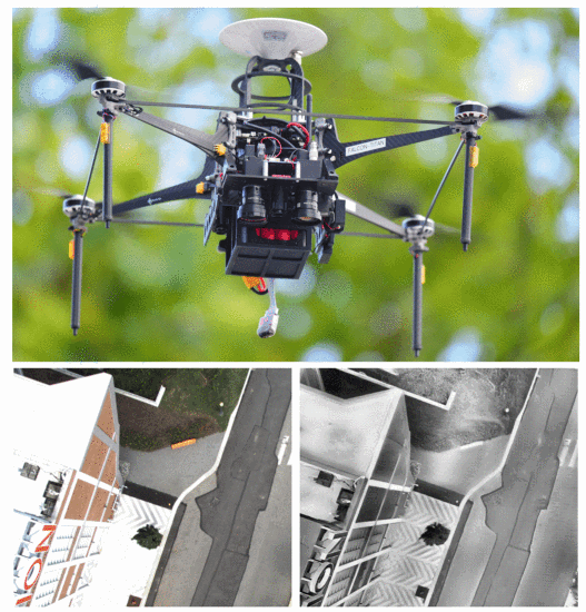
Top: The Falcon 4 aerial platform is used for high-altitude experiments. The EvMAPPER sensor stack is mounted at the front. It is comprised of an IMU, a range sensor, an RGB camera, an event camera, and a synchronization board. Bottom left: artifacts of CMOS-based cameras in high-altitude photography: the sidewalk is washed out due to the limited dynamic range of the sensor. Bottom right: reconstructed frame with event cameras displaying a higher level of detail in challenging light conditions.